

Of all the unique and essential jobs and professions at TxDOT, the least known and perhaps hardest to pronounce is this one: photogrammetrist (fō-tə-ˈgra-mə-trist).
TxDOT has 13 photogrammetrists, all working out of its Design Division at the Riverside complex in Austin. The group has become accustomed to answering lots of questions about their occupation. They say it's like a job, all by itself.
Here's a hint about what they do: According to Merriam-Webster, photogrammetry is "the science of making reliable measurements by the use of photographs and especially aerial photographs (as in surveying)."
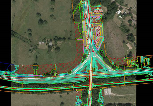
"It's all about building roads and building them right," explains John Dulski, who heads up TxDOT's team of photogrammetrists. "Road designers and builders need us because we supply them with three-dimensional (3-D), topographical depictions of the area. As a result, they can determine how much concrete they need, for example, or how much dirt has to be removed or added, and what drainage issues they will encounter, and where. All of that and much more has to be determined, and it can't be done accurately without our work."
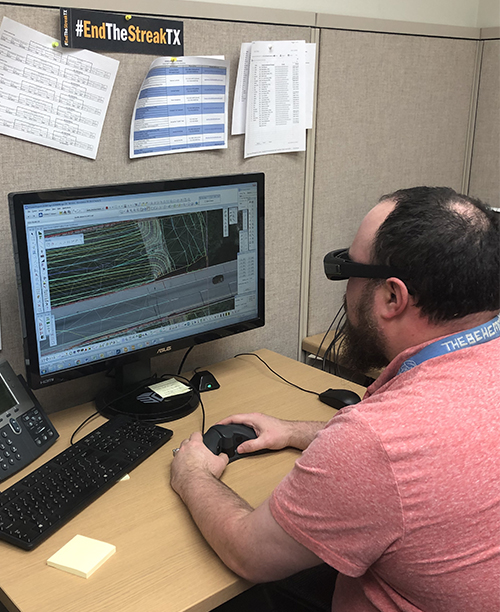
It all starts with photographs, usually taken by a fixed-wing airplane (though drones can be used too, especially in remote locations). Photogrammetrists will combine photos of the area taken from multiple angles with information supplied by surveyors, global positioning system data and existing maps. A specially designed software, along with glasses similar to those used to view 3-D movies, enable the technicians to see the photos in three dimensions, allowing them to create the final product: a highly accurate, 3-D model of the ground's surface. The level of detail needed varies with the task, but the aerial cameras can take photos from a height up to 1,500 feet that can be viewed accurately down to a square only 2 centimeters wide.
"It's a real labor of love. I love what I do and I like talking about it," exclaims Jacqueline King, a TxDOT photogrammetrist for the past three years. "We work with the same types of materials and data sources for each project, but what's fascinating is seeing and working with all the different geographical regions in the state. And to offer roadway designers an accurate 3-D surface is very satisfying."
Most photogrammetrists don't go to college to be one. In fact, there are no photogrammetry schools, although some geography and geology classes may have a section dedicated to it. Cartography (the science of map drawing) is considered a recommended class for photogrammetrist wannabes.
"I thought I wanted to be an astronaut, but couldn't get past some of the required math courses, like Calculus III, for aerospace engineering," chuckles James Dalton, one of TxDOT's photogrammetrists. "I stuck to geography, and that's what my degree is in. My love for photogrammetry evolved, with the skills developing through on-the-job training."
In reality, photogrammetrists are more common than people might think. In addition to this essential work for road design, many work for the military (photogrammetry was an important field during World War Two and is still a vital element for planning), private engineering firms and federal agencies like the U.S. Geological Survey. Photogrammetrists can even help predict when volcanos will erupt, based on the ground changes observed near craters.
"It's amazing that all this work takes place and no one knows about it," Dulski says. He's spent 32 years as a photogrammetrist and is excited about his profession finally being described to the public. "I may print off lots of copies of this and hand them out."

Jake Smith
I-35 Public Information Officer
254-867-2705
Contact My35
![]()